Watches /
RWI-W-CARIB
Regional benchmark — Windward Passage & Caribbean
Windward Passage & Caribbean
RWI-W-CARIB-2026-11-04flights 2026-11-03
Nothing out of pattern.
no flights kept · 13 heat (0 on sites)
Full report
Windward Passage & Caribbean. Daily open-source look; flights for 2026-11-03 (UTC), heat for 2026-11-03–2026-11-04, newest satellite passes. LLM-generated and automated.
Notable
- Nothing out of pattern.
Flights
The adsb.lol archive for 2026-11-03 is not published yet; the next run fills it in.
Heat
13 detections in the watch box (FIRMS area API (agent Gazda)); 0 inside a site box. Pre-alpha sample basis (frozen 2 Nov 2026).
| Date | UTC | Lat, lon | FRP | Satellite | Site / nearest |
|---|---|---|---|---|---|
| 2026-11-03 | 0631 | 19.675, -71.702 | 0.78 | N21 | Toussaint Louverture International Airport (MTPP) (137.3 km) |
| 2026-11-03 | 1743 | 18.274, -70.139 | 5.85 | N21 | Toussaint Louverture International Airport (MTPP) (229.9 km) |
| 2026-11-03 | 1743 | 18.322, -70.398 | 5.89 | N21 | Toussaint Louverture International Airport (MTPP) (202.1 km) |
| 2026-11-03 | 1743 | 18.322, -70.441 | 9.24 | N21 | Toussaint Louverture International Airport (MTPP) (197.6 km) |
| 2026-11-03 | 1743 | 18.325, -70.398 | 5.69 | N21 | Toussaint Louverture International Airport (MTPP) (202.0 km) |
| 2026-11-03 | 1743 | 18.326, -70.437 | 34.2 | N21 | Toussaint Louverture International Airport (MTPP) (197.9 km) |
| 2026-11-03 | 1743 | 18.329, -70.399 | 5.69 | N21 | Toussaint Louverture International Airport (MTPP) (201.9 km) |
| 2026-11-03 | 1743 | 18.333, -70.400 | 10.19 | N21 | Toussaint Louverture International Airport (MTPP) (201.7 km) |
| 2026-11-03 | 1743 | 18.488, -70.056 | 2.12 | N21 | Toussaint Louverture International Airport (MTPP) (236.3 km) |
| 2026-11-03 | 1743 | 18.575, -72.252 | 4.08 | N21 | Toussaint Louverture International Airport (MTPP) (4.5 km) |
| 2026-11-03 | 1743 | 19.117, -70.192 | 3.16 | N21 | Toussaint Louverture International Airport (MTPP) (229.3 km) |
| 2026-11-03 | 1743 | 19.198, -70.232 | 3.64 | N21 | Toussaint Louverture International Airport (MTPP) (227.8 km) |
| 2026-11-03 | 1925 | 22.785, -82.443 | 6.26 | N21 | Bejucal SIGINT site (19.9 km) |
Imagery
| Site | Newest clear Sentinel-2 pass (≤12 days) | |
|---|---|---|
| Naval Station Guantánamo Bay – Windward side / harbour | 2026-11-01 15:37 UTC, 85% clear | no new pass |
| Leeward Point Field (MUGM) | 2026-10-30 15:47 UTC, 100% clear | no new pass |
| Former NS Roosevelt Roads (Ceiba, PR) | 2026-10-28 15:07 UTC, 88% clear | no new pass |
| José Aponte de la Torre Airport (TJRV) | 2026-10-28 15:07 UTC, 82% clear | no new pass |
| El Salao CDAA (Santiago de Cuba) | 2026-10-30 15:47 UTC, 99% clear | no new pass |
| Toussaint Louverture International Airport (MTPP) | 2026-10-29 15:28 UTC, 93% clear | no new pass |
RWI-W-CARIB-2026-11-01flights 2026-10-31
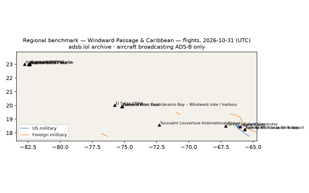
- 3 foreign military aircraft in the area (Australia, Brazil, other).
3 US military · 59 other low · 3 foreign military · 49 heat (0 on sites)
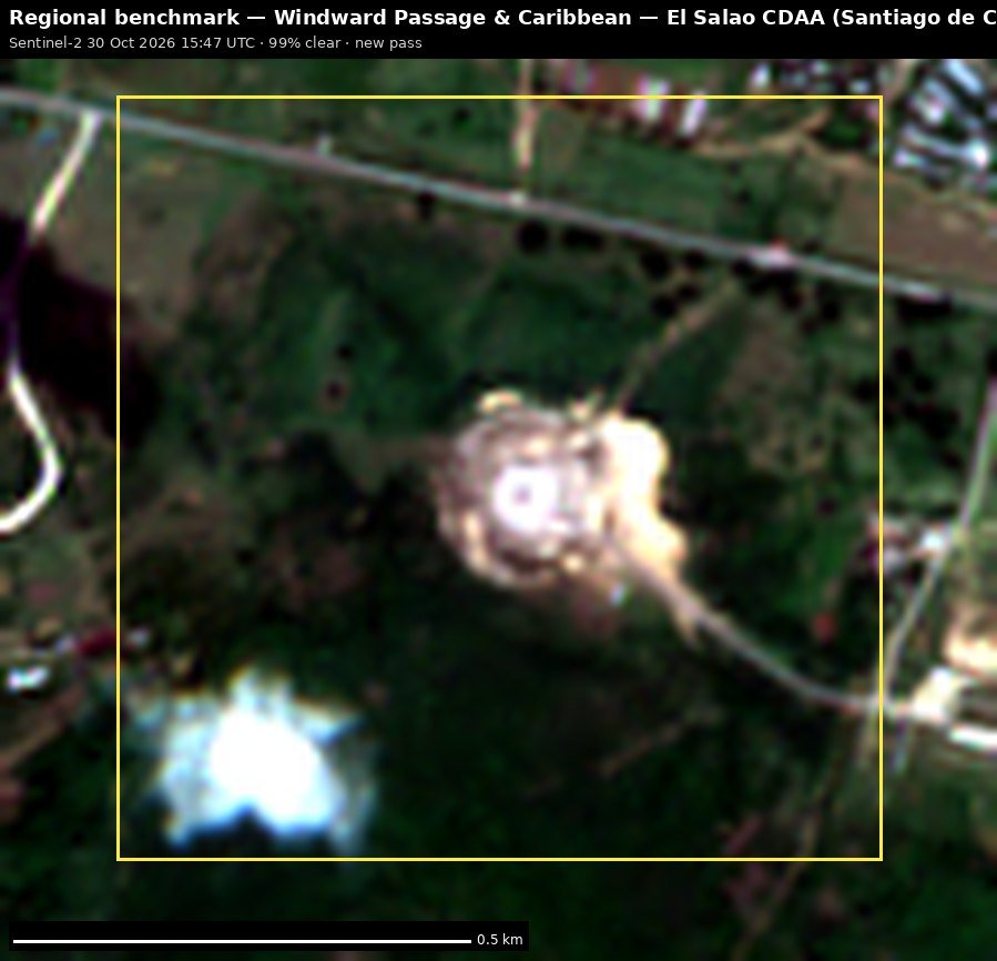 El Salao CDAA (Santiago de Cuba)
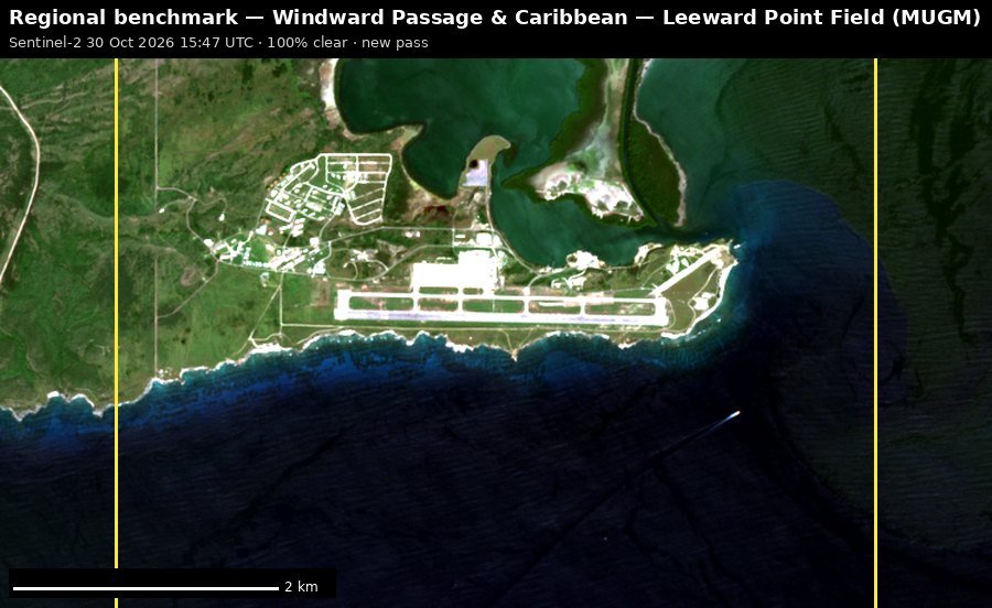 Leeward Point Field (MUGM)
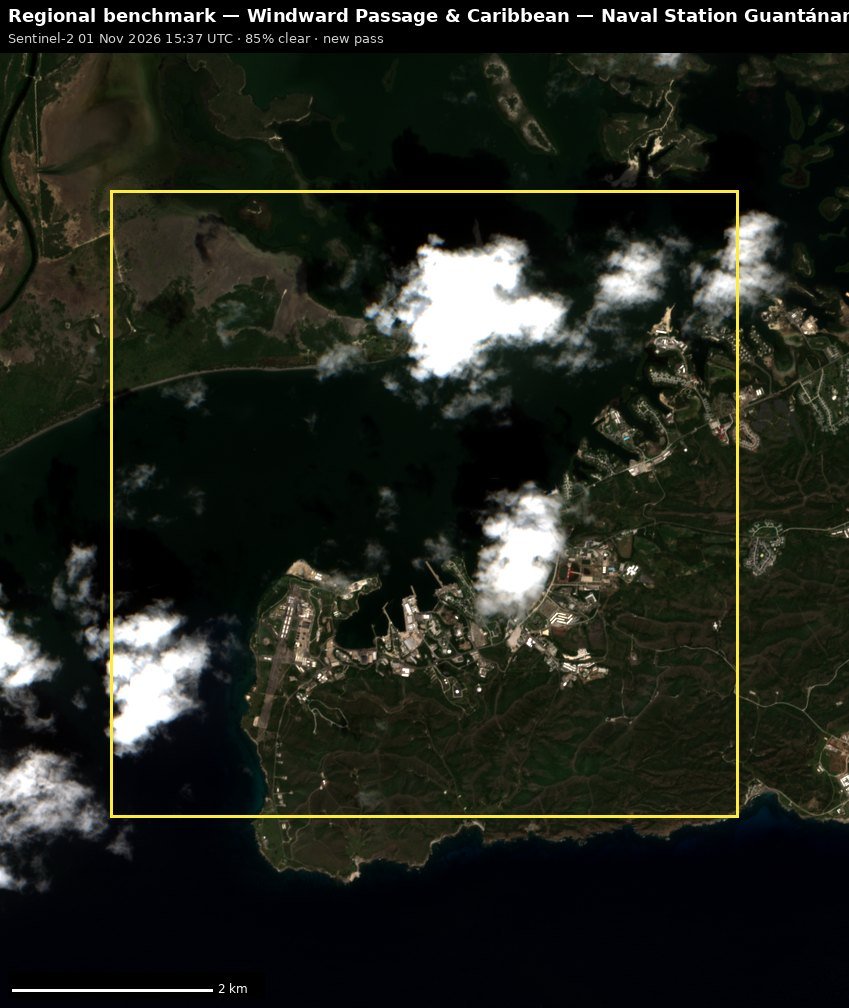 Naval Station Guantánamo Bay – Windward side / harbour
 Toussaint Louverture International Airport (MTPP)
 José Aponte de la Torre Airport (TJRV)
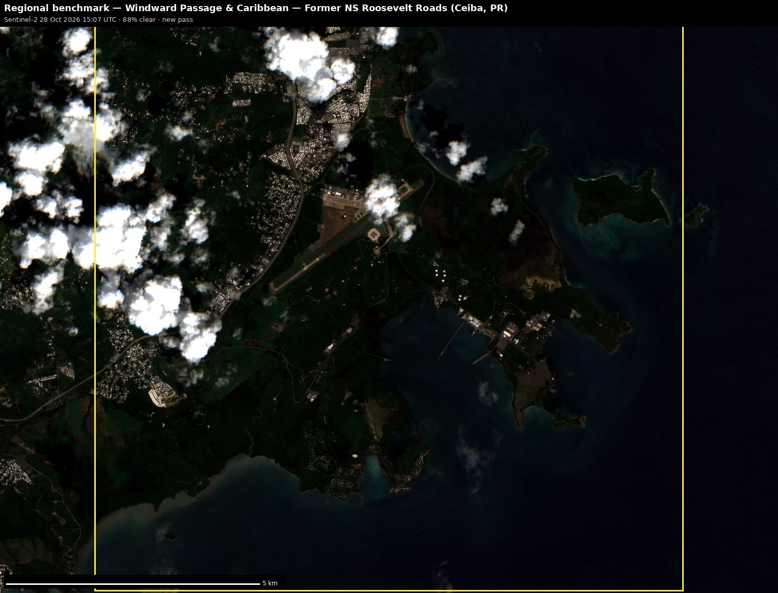 Former NS Roosevelt Roads (Ceiba, PR)
Full report
Windward Passage & Caribbean. Daily open-source look; flights for 2026-10-31 (UTC), heat for 2026-10-31–2026-11-01, newest satellite passes. LLM-generated and automated.
Notable
- 3 foreign military aircraft in the area (Australia, Brazil, other).
Flights
65 aircraft kept: 3 US military, 3 foreign military, 0 state/VIP, 59 other (on the ground at a site, or near a range).
US military
H60 ×1, C17 ×1, D328 ×1.
- 6038 H60 C6038 at Muñiz ANGB 14:36 UTC
- 08-8196 C17 RCH690 at Muñiz ANGB 06:38 UTC
- 12-3047 D328 at Muñiz ANGB 22:02 UTC
Foreign military
- Australia: A39-007 A332 ASY334 21:34–21:54 UTC
- other: FAD7505 TUCR FAD7509 12:31–12:40 UTC
- Brazil: e40090 IWY774 23:14–23:47 UTC
Landings and low passes by site
| Site | Military / government aircraft on the ground or ≤1,500 ft within 4 km; civil count |
|---|---|
| Naval Station Guantánamo Bay – Windward side / harbour | — |
| Leeward Point Field (MUGM) | — |
| Former NS Roosevelt Roads (Ceiba, PR) | — |
| José Aponte de la Torre Airport (TJRV) | — |
| Lourdes SIGINT station (former) | — |
| Bejucal SIGINT site | — |
| Wajay SIGINT site | — |
| Calabazar SIGINT site | — |
| El Salao CDAA (Santiago de Cuba) | — |
| Toussaint Louverture International Airport (MTPP) | — |
| Ramey / Rafael Hernández | — |
| Muñiz ANGB | 08-8196 C17 (RCH690) 06:38, 6038 H60 (C6038) 14:36, 12-3047 D328 22:02; 42 civil |
| Port of Mariel | — |
Heat
49 detections in the watch box (FIRMS area API (agent Gazda)); 0 inside a site box. Pre-alpha sample basis (frozen 2 Nov 2026).
| Date | UTC | Lat, lon | FRP | Satellite | Site / nearest |
|---|---|---|---|---|---|
| 2026-10-31 | 0548 | 19.483, -70.759 | 1.53 | N21 | Toussaint Louverture International Airport (MTPP) (190.5 km) |
| 2026-10-31 | 0548 | 19.675, -71.702 | 0.73 | N21 | Toussaint Louverture International Airport (MTPP) (137.3 km) |
| 2026-10-31 | 0548 | 19.677, -71.702 | 0.63 | N21 | Toussaint Louverture International Airport (MTPP) (137.5 km) |
| 2026-10-31 | 0646 | 18.383, -78.045 | 1.33 | N20 | El Salao CDAA (Santiago de Cuba) (301.3 km) |
| 2026-10-31 | 0646 | 19.676, -71.702 | 0.68 | N20 | Toussaint Louverture International Airport (MTPP) (137.3 km) |
| 2026-10-31 | 1403 | 20.047, -74.839 | 9.29 | Terra | Naval Station Guantánamo Bay – Windward side / harbour (35.2 km) |
| 2026-10-31 | 1403 | 20.049, -74.853 | 8.63 | Terra | Naval Station Guantánamo Bay – Windward side / harbour (34.0 km) |
| 2026-10-31 | 1756 | 18.575, -70.057 | 5.17 | N20 | Toussaint Louverture International Airport (MTPP) (235.9 km) |
| 2026-10-31 | 1758 | 21.831, -78.496 | 8.76 | N20 | El Salao CDAA (Santiago de Cuba) (350.3 km) |
| 2026-10-31 | 1758 | 21.982, -78.740 | 2.78 | N20 | El Salao CDAA (Santiago de Cuba) (380.6 km) |
| 2026-10-31 | 1758 | 22.722, -81.969 | 6.57 | N20 | Bejucal SIGINT site (47.6 km) |
| 2026-10-31 | 1841 | 18.597, -74.051 | 6.69 | N21 | Toussaint Louverture International Airport (MTPP) (185.1 km) |
| 2026-10-31 | 1841 | 18.598, -74.054 | 6.61 | N21 | Toussaint Louverture International Airport (MTPP) (185.4 km) |
| 2026-10-31 | 1841 | 21.177, -76.578 | 3.05 | N21 | El Salao CDAA (Santiago de Cuba) (156.3 km) |
| 2026-10-31 | 1841 | 21.661, -79.253 | 3.54 | N21 | Bejucal SIGINT site (350.5 km) |
| 2026-10-31 | 1841 | 21.665, -79.254 | 3.54 | N21 | Bejucal SIGINT site (350.2 km) |
| 2026-10-31 | 1841 | 21.831, -78.496 | 11.24 | N21 | El Salao CDAA (Santiago de Cuba) (350.3 km) |
| 2026-10-31 | 1841 | 21.832, -78.498 | 14.4 | N21 | El Salao CDAA (Santiago de Cuba) (350.6 km) |
| 2026-10-31 | 1843 | 22.731, -82.035 | 1.63 | N21 | Bejucal SIGINT site (41.4 km) |
| 2026-10-31 | 2008 | 19.571, -71.639 | 22.57 | Aqua | Toussaint Louverture International Airport (MTPP) (130.4 km) |
| 2026-10-31 | 2008 | 20.682, -75.598 | 58.95 | Aqua | El Salao CDAA (Santiago de Cuba) (76.8 km) |
| 2026-10-31 | 2008 | 20.686, -75.578 | 19.7 | Aqua | El Salao CDAA (Santiago de Cuba) (77.7 km) |
| 2026-11-01 | 0605 | 19.693, -71.488 | 0.77 | N | Toussaint Louverture International Airport (MTPP) (150.5 km) |
| 2026-11-01 | 0626 | 18.874, -70.310 | 0.57 | N20 | Toussaint Louverture International Airport (MTPP) (211.7 km) |
| 2026-11-01 | 0626 | 19.677, -71.704 | 0.77 | N20 | Toussaint Louverture International Airport (MTPP) (137.3 km) |
| 2026-11-01 | 0626 | 19.695, -71.488 | 0.65 | N20 | Toussaint Louverture International Airport (MTPP) (150.6 km) |
| 2026-11-01 | 0626 | 21.986, -79.310 | 0.68 | N20 | Calabazar SIGINT site (330.9 km) |
| 2026-11-01 | 0745 | 21.988, -79.306 | 0.58 | N | Calabazar SIGINT site (331.2 km) |
| 2026-11-01 | 1717 | 19.188, -70.312 | 2.71 | N | Toussaint Louverture International Airport (MTPP) (219.5 km) |
| 2026-11-01 | 1738 | 20.585, -76.051 | 4.07 | N20 | El Salao CDAA (Santiago de Cuba) (71.8 km) |
| 2026-11-01 | 1821 | 20.313, -77.049 | 3.1 | N21 | El Salao CDAA (Santiago de Cuba) (140.2 km) |
| 2026-11-01 | 1821 | 20.585, -76.053 | 8.96 | N21 | El Salao CDAA (Santiago de Cuba) (71.9 km) |
| 2026-11-01 | 1821 | 20.585, -76.049 | 3.42 | N21 | El Salao CDAA (Santiago de Cuba) (71.7 km) |
| 2026-11-01 | 1821 | 22.074, -80.521 | 6.07 | N21 | Bejucal SIGINT site (212.7 km) |
| 2026-11-01 | 1821 | 22.163, -80.598 | 5.73 | N21 | Bejucal SIGINT site (201.2 km) |
| 2026-11-01 | 1821 | 22.172, -80.035 | 6.13 | N21 | Calabazar SIGINT site (253.8 km) |
| 2026-11-01 | 1821 | 22.173, -80.031 | 4.22 | N21 | Calabazar SIGINT site (254.1 km) |
| 2026-11-01 | 1821 | 22.191, -80.412 | 5.5 | N21 | Bejucal SIGINT site (217.3 km) |
| 2026-11-01 | 1821 | 22.194, -80.413 | 5.5 | N21 | Bejucal SIGINT site (217.1 km) |
| 2026-11-01 | 1821 | 22.204, -80.785 | 4.81 | N21 | Bejucal SIGINT site (181.9 km) |
Imagery
| Site | Newest clear Sentinel-2 pass (≤12 days) | |
|---|---|---|
| Naval Station Guantánamo Bay – Windward side / harbour | 2026-11-01 15:37 UTC, 85% clear | new plate |
| Leeward Point Field (MUGM) | 2026-10-30 15:47 UTC, 100% clear | new plate |
| Former NS Roosevelt Roads (Ceiba, PR) | 2026-10-28 15:07 UTC, 88% clear | new plate |
| José Aponte de la Torre Airport (TJRV) | 2026-10-28 15:07 UTC, 82% clear | new plate |
| El Salao CDAA (Santiago de Cuba) | 2026-10-30 15:47 UTC, 99% clear | new plate |
| Toussaint Louverture International Airport (MTPP) | 2026-10-29 15:28 UTC, 93% clear | new plate |