Watches /
RWI-W-NORCAL
NorCal Watch
Northern and central California — airlift, reconnaissance, the weapons lab and the depots
RWI-W-NORCAL-2026-11-04flights 2026-11-03
Nothing out of pattern.
no flights kept · 22 heat (0 on sites)
Full report
Northern and central California — airlift, reconnaissance, the weapons lab and the depots. Daily open-source look; flights for 2026-11-03 (UTC), heat for 2026-11-03–2026-11-04, newest satellite passes. LLM-generated and automated.
Notable
- Nothing out of pattern.
Flights
The adsb.lol archive for 2026-11-03 is not published yet; the next run fills it in.
Heat
22 detections in the watch box (FIRMS area API (agent Gazda)); 0 inside a site box. The Central Valley has seasonal agricultural burning; only heat on a site box is flagged.
| Date | UTC | Lat, lon | FRP | Satellite | Site / nearest |
|---|---|---|---|---|---|
| 2026-11-03 | 0949 | 36.972, -120.873 | 0.36 | N21 | Lawrence Livermore National Laboratory (108.5 km) |
| 2026-11-03 | 0949 | 37.183, -121.678 | 0.73 | N21 | Moffett Field (NASA Ames) (41.8 km) |
| 2026-11-03 | 0949 | 37.453, -121.933 | 0.54 | N21 | Moffett Field (NASA Ames) (11.2 km) |
| 2026-11-03 | 0949 | 37.456, -121.932 | 0.65 | N21 | Moffett Field (NASA Ames) (11.4 km) |
| 2026-11-03 | 0949 | 37.755, -121.661 | 0.56 | N21 | Lawrence Livermore National Laboratory (8.6 km) |
| 2026-11-03 | 0949 | 37.883, -121.187 | 0.68 | N21 | Lawrence Livermore National Laboratory (50.6 km) |
| 2026-11-03 | 0949 | 37.884, -121.201 | 0.53 | N21 | Lawrence Livermore National Laboratory (49.6 km) |
| 2026-11-03 | 0949 | 37.941, -122.391 | 0.93 | N21 | Military Ocean Terminal Concord (34.2 km) |
| 2026-11-03 | 0949 | 37.949, -122.399 | 1.17 | N21 | Military Ocean Terminal Concord (34.6 km) |
| 2026-11-03 | 0949 | 38.003, -121.934 | 0.85 | N21 | Military Ocean Terminal Concord (9.5 km) |
| 2026-11-03 | 0949 | 38.316, -121.835 | 0.36 | N21 | Travis AFB (10.2 km) |
| 2026-11-03 | 0949 | 39.093, -121.624 | 0.53 | N21 | Beale AFB (16.9 km) |
| 2026-11-03 | 0949 | 39.128, -122.205 | 1.57 | N21 | Beale AFB (66.4 km) |
| 2026-11-03 | 0949 | 39.261, -120.446 | 1.71 | N21 | Beale AFB (86.4 km) |
| 2026-11-03 | 0949 | 39.689, -122.160 | 0.49 | N21 | Beale AFB (87.6 km) |
| 2026-11-03 | 1047 | 39.131, -122.204 | 1.77 | N20 | Beale AFB (66.3 km) |
| 2026-11-03 | 1049 | 38.016, -122.116 | 2.29 | N20 | Military Ocean Terminal Concord (8.9 km) |
| 2026-11-03 | 1049 | 38.017, -122.117 | 1.39 | N20 | Military Ocean Terminal Concord (8.9 km) |
| 2026-11-03 | 2112 | 37.540, -120.998 | 2.04 | N21 | Lawrence Livermore National Laboratory (64.6 km) |
| 2026-11-03 | 2112 | 37.836, -121.197 | 2.17 | N21 | Lawrence Livermore National Laboratory (47.8 km) |
| 2026-11-03 | 2207 | 37.283, -120.843 | 20.26 | N20 | Lawrence Livermore National Laboratory (88.5 km) |
| 2026-11-03 | 2208 | 37.282, -120.846 | 20.25 | N20 | Lawrence Livermore National Laboratory (88.4 km) |
Imagery
| Site | Newest clear Sentinel-2 pass (≤12 days) | |
|---|---|---|
| Travis AFB | 2026-10-30 19:03 UTC, 81% clear | no new pass |
| Beale AFB | none clear | |
| Lawrence Livermore National Laboratory | none clear | |
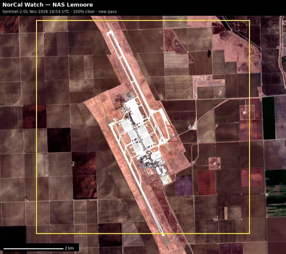
| NAS Lemoore | 2026-11-01 18:54 UTC, 100% clear | no new pass |
| Sierra Army Depot | 2026-11-01 18:53 UTC, 100% clear | no new pass |
RWI-W-NORCAL-2026-11-03flights 2026-11-02
Nothing out of pattern.
31 US military · 25 other low · 38 heat (0 on sites)

Full report
Northern and central California — airlift, reconnaissance, the weapons lab and the depots. Daily open-source look; flights for 2026-11-02 (UTC), heat for 2026-11-02–2026-11-03, newest satellite passes. LLM-generated and automated.
Notable
- Nothing out of pattern.
Flights
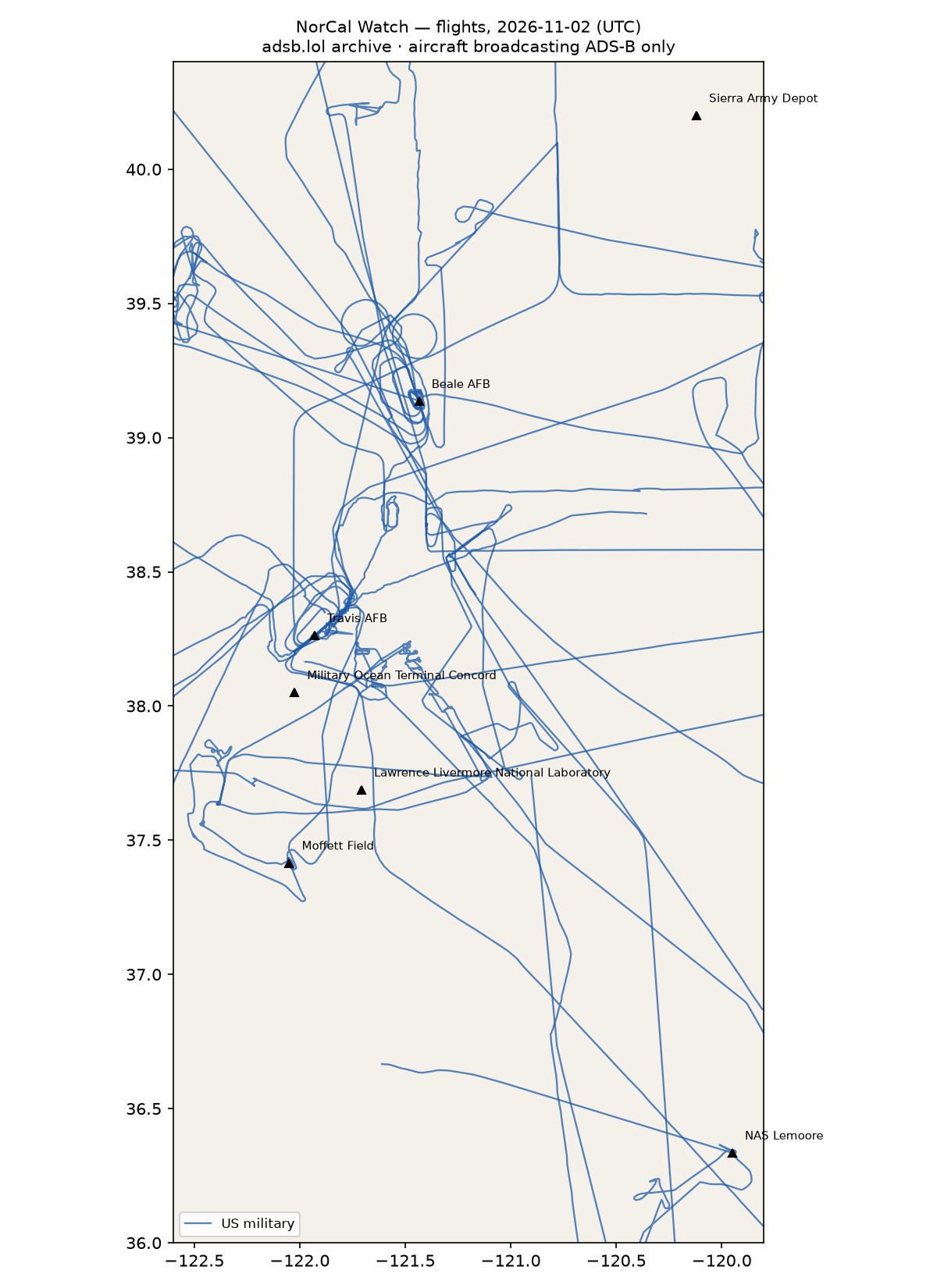
56 aircraft kept: 31 US military, 0 Canadian military, 0 foreign military, 0 state/VIP, 25 other (on the ground at a site, or near a range).
US military
C17 ×5, H60 ×5, T38 ×3, AS65 ×2, C5M ×2, C30J ×2, B762 ×2, C27J ×2, H47 ×2, T34T ×1, BE20 ×1, ? ×1, GLF5 ×1, C172 ×1, P8 ×1.
- 160949 T34T DAWG1 at NAS Lemoore 18:51 UTC
- 64-13270 T38 ROPER12 SLATE22 at Beale AFB 16:29 UTC
- 6597 AS65 C6597 at Moffett Field 18:27 UTC
- 06-6161 C17 RCH8051 at Travis AFB 13:19 UTC
- 68-0213 C5M FRED15 at Travis AFB 19:51 UTC
- 65-10342 T38 ROPER32 at Beale AFB 23:21 UTC
- 14-5864 C30J KING54 at Moffett Field 15:41, Travis AFB 16:12 UTC
- 64-13285 T38 ROPER31 SLATE21 at Beale AFB 19:55 UTC
- 165755 H60 LASSO01 at NAS Lemoore 16:19 UTC
- 94-0068 C17 SLAM91 at Travis AFB 20:45 UTC
Foreign military
None broadcasting.
Landings and low passes by site
| Site | Military / government aircraft on the ground or ≤1,500 ft within 4 km; civil count |
|---|---|
| Travis AFB | 06-6161 C17 (RCH8051) 13:19, 14-5864 C30J (KING54) 16:12, 68-0213 C5M (FRED15) 19:51, 94-0068 C17 (SLAM91) 20:45; 2 civil |
| Beale AFB | 64-13270 T38 (ROPER12 SLATE22) 16:29, 64-13285 T38 (ROPER31 SLATE21) 19:55, 65-10342 T38 (ROPER32) 23:21 |
| Lawrence Livermore National Laboratory | 1 civil |
| Moffett Field (NASA Ames) | 14-5864 C30J (KING54) 15:41, 6597 AS65 (C6597) 18:27; 15 civil |
| Military Ocean Terminal Concord | — |
| NAS Lemoore | 165755 H60 (LASSO01) 16:19, 160949 T34T (DAWG1) 18:51 |
| Sierra Army Depot | — |
Heat
38 detections in the watch box (FIRMS area API (agent Gazda)); 0 inside a site box. The Central Valley has seasonal agricultural burning; only heat on a site box is flagged.
| Date | UTC | Lat, lon | FRP | Satellite | Site / nearest |
|---|---|---|---|---|---|
| 2026-11-02 | 0926 | 36.693, -120.583 | 1.34 | N20 | NAS Lemoore (69.2 km) |
| 2026-11-02 | 0926 | 37.455, -121.934 | 0.44 | N20 | Moffett Field (NASA Ames) (11.2 km) |
| 2026-11-02 | 0926 | 38.015, -122.115 | 0.77 | N20 | Military Ocean Terminal Concord (8.8 km) |
| 2026-11-02 | 0926 | 38.015, -122.118 | 0.77 | N20 | Military Ocean Terminal Concord (9.1 km) |
| 2026-11-02 | 0926 | 38.018, -122.117 | 1.37 | N20 | Military Ocean Terminal Concord (8.8 km) |
| 2026-11-02 | 1010 | 36.694, -120.585 | 1 | N21 | NAS Lemoore (69.3 km) |
| 2026-11-02 | 1010 | 37.455, -121.932 | 1.29 | N21 | Moffett Field (NASA Ames) (11.3 km) |
| 2026-11-02 | 1047 | 36.695, -120.580 | 0.99 | N | NAS Lemoore (69.1 km) |
| 2026-11-02 | 1654 | 38.431, -122.274 | 18.49 | Terra | Travis AFB (35.3 km) |
| 2026-11-02 | 1654 | 39.261, -120.447 | 9.21 | Terra | Beale AFB (86.3 km) |
| 2026-11-02 | 2046 | 36.696, -120.009 | 5.35 | N20 | NAS Lemoore (40.4 km) |
| 2026-11-02 | 2046 | 38.066, -120.252 | 10.92 | N20 | Lawrence Livermore National Laboratory (134.5 km) |
| 2026-11-02 | 2048 | 39.262, -120.443 | 7.25 | N20 | Beale AFB (86.7 km) |
| 2026-11-02 | 2129 | 38.066, -120.252 | 4.57 | N21 | Lawrence Livermore National Laboratory (134.5 km) |
| 2026-11-02 | 2131 | 39.412, -122.248 | 35.06 | N21 | Beale AFB (76.5 km) |
| 2026-11-02 | 2131 | 39.413, -122.244 | 35.06 | N21 | Beale AFB (76.2 km) |
| 2026-11-03 | 0949 | 36.972, -120.873 | 0.36 | N21 | Lawrence Livermore National Laboratory (108.5 km) |
| 2026-11-03 | 0949 | 37.183, -121.678 | 0.73 | N21 | Moffett Field (NASA Ames) (41.8 km) |
| 2026-11-03 | 0949 | 37.453, -121.933 | 0.54 | N21 | Moffett Field (NASA Ames) (11.2 km) |
| 2026-11-03 | 0949 | 37.456, -121.932 | 0.65 | N21 | Moffett Field (NASA Ames) (11.4 km) |
| 2026-11-03 | 0949 | 37.755, -121.661 | 0.56 | N21 | Lawrence Livermore National Laboratory (8.6 km) |
| 2026-11-03 | 0949 | 37.883, -121.187 | 0.68 | N21 | Lawrence Livermore National Laboratory (50.6 km) |
| 2026-11-03 | 0949 | 37.884, -121.201 | 0.53 | N21 | Lawrence Livermore National Laboratory (49.6 km) |
| 2026-11-03 | 0949 | 37.941, -122.391 | 0.93 | N21 | Military Ocean Terminal Concord (34.2 km) |
| 2026-11-03 | 0949 | 37.949, -122.399 | 1.17 | N21 | Military Ocean Terminal Concord (34.6 km) |
| 2026-11-03 | 0949 | 38.003, -121.934 | 0.85 | N21 | Military Ocean Terminal Concord (9.5 km) |
| 2026-11-03 | 0949 | 38.316, -121.835 | 0.36 | N21 | Travis AFB (10.2 km) |
| 2026-11-03 | 0949 | 39.093, -121.624 | 0.53 | N21 | Beale AFB (16.9 km) |
| 2026-11-03 | 0949 | 39.128, -122.205 | 1.57 | N21 | Beale AFB (66.4 km) |
| 2026-11-03 | 0949 | 39.261, -120.446 | 1.71 | N21 | Beale AFB (86.4 km) |
| 2026-11-03 | 0949 | 39.689, -122.160 | 0.49 | N21 | Beale AFB (87.6 km) |
| 2026-11-03 | 1047 | 39.131, -122.204 | 1.77 | N20 | Beale AFB (66.3 km) |
| 2026-11-03 | 1049 | 38.016, -122.116 | 2.29 | N20 | Military Ocean Terminal Concord (8.9 km) |
| 2026-11-03 | 1049 | 38.017, -122.117 | 1.39 | N20 | Military Ocean Terminal Concord (8.9 km) |
| 2026-11-03 | 2112 | 37.540, -120.998 | 2.04 | N21 | Lawrence Livermore National Laboratory (64.6 km) |
| 2026-11-03 | 2112 | 37.836, -121.197 | 2.17 | N21 | Lawrence Livermore National Laboratory (47.8 km) |
| 2026-11-03 | 2207 | 37.283, -120.843 | 20.26 | N20 | Lawrence Livermore National Laboratory (88.5 km) |
| 2026-11-03 | 2208 | 37.282, -120.846 | 20.25 | N20 | Lawrence Livermore National Laboratory (88.4 km) |
Imagery
| Site | Newest clear Sentinel-2 pass (≤12 days) | |
|---|---|---|
| Travis AFB | 2026-10-30 19:03 UTC, 81% clear | no new pass |
| Beale AFB | none clear | |
| Lawrence Livermore National Laboratory | none clear | |
| NAS Lemoore | 2026-11-01 18:54 UTC, 100% clear | no new pass |
| Sierra Army Depot | 2026-11-01 18:53 UTC, 100% clear | no new pass |
RWI-W-NORCAL-2026-11-01flights 2026-10-31
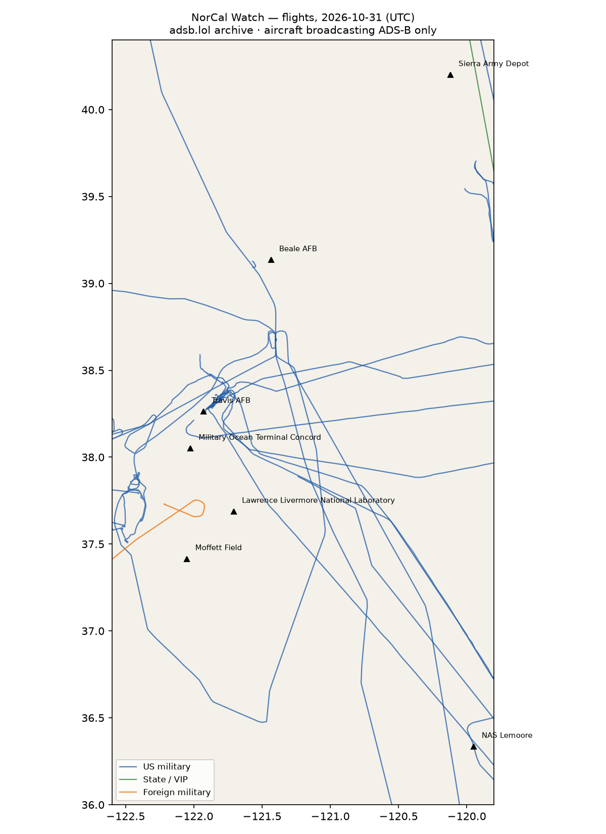
- 1 foreign military aircraft in the area (Germany).
23 other low · 18 US military · 1 state/VIP · 1 foreign military · 84 heat (0 on sites)
Full report
Northern and central California — airlift, reconnaissance, the weapons lab and the depots. Daily open-source look; flights for 2026-10-31 (UTC), heat for 2026-10-31–2026-11-01, newest satellite passes. LLM-generated and automated.
Notable
- 1 foreign military aircraft in the area (Germany).
Flights
43 aircraft kept: 18 US military, 1 foreign military, 1 state/VIP, 23 other (on the ground at a site, or near a range).
US military
C17 ×3, C5M ×3, C27J ×2, ? ×2, BE20 ×1, H60 ×1, B737 ×1, H47 ×1, C30J ×1, C172 ×1, EC45 ×1, AS65 ×1.
- 05-5141 C17 RCH0216 at Travis AFB 08:03 UTC
- 87-0044 C5M RCH2181 at Travis AFB 01:37 UTC
- 166694 B737 CNV4118 at NAS Lemoore 00:52 UTC
Foreign military
- Germany: 54+19 A400 02 @@@@ @@@@@@@@ AF102 @ F102 @@ GAF102 22:08–22:51 UTC
State and VIP
- UR-82027 A124 ANTONOV An-124 Ruslan ADB503F 14:39–16:24 UTC
Landings and low passes by site
| Site | Military / government aircraft on the ground or ≤1,500 ft within 4 km; civil count |
|---|---|
| Travis AFB | 87-0044 C5M (RCH2181) 01:37, 05-5141 C17 (RCH0216) 08:03; 2 civil |
| Beale AFB | — |
| Lawrence Livermore National Laboratory | — |
| Moffett Field (NASA Ames) | 10 civil |
| Military Ocean Terminal Concord | — |
| NAS Lemoore | 166694 B737 (CNV4118) 00:52 |
| Sierra Army Depot | — |
Heat
84 detections in the watch box (FIRMS area API (agent Gazda)); 0 inside a site box. The Central Valley has seasonal agricultural burning; only heat on a site box is flagged.
| Date | UTC | Lat, lon | FRP | Satellite | Site / nearest |
|---|---|---|---|---|---|
| 2026-10-31 | 0905 | 37.948, -122.399 | 1.29 | N21 | Military Ocean Terminal Concord (34.6 km) |
| 2026-10-31 | 0943 | 37.454, -121.935 | 0.48 | N | Moffett Field (NASA Ames) (11.1 km) |
| 2026-10-31 | 0943 | 38.015, -122.112 | 0.85 | N | Military Ocean Terminal Concord (8.6 km) |
| 2026-10-31 | 0943 | 39.130, -122.201 | 2.43 | N | Beale AFB (66.1 km) |
| 2026-10-31 | 0943 | 39.264, -120.442 | 3.21 | N | Beale AFB (86.8 km) |
| 2026-10-31 | 1004 | 37.186, -121.682 | 0.28 | N20 | Moffett Field (NASA Ames) (41.3 km) |
| 2026-10-31 | 1004 | 37.456, -121.933 | 0.68 | N20 | Moffett Field (NASA Ames) (11.3 km) |
| 2026-10-31 | 1004 | 37.756, -121.662 | 0.31 | N20 | Lawrence Livermore National Laboratory (8.6 km) |
| 2026-10-31 | 1004 | 38.014, -122.114 | 0.66 | N20 | Military Ocean Terminal Concord (8.7 km) |
| 2026-10-31 | 1004 | 38.216, -121.984 | 0.36 | N20 | Travis AFB (7.0 km) |
| 2026-10-31 | 1004 | 39.129, -122.204 | 2.18 | N20 | Beale AFB (66.3 km) |
| 2026-10-31 | 1004 | 39.133, -122.203 | 0.74 | N20 | Beale AFB (66.3 km) |
| 2026-10-31 | 1045 | 38.013, -122.113 | 1.19 | N21 | Military Ocean Terminal Concord (8.7 km) |
| 2026-10-31 | 1045 | 38.013, -122.115 | 0.9 | N21 | Military Ocean Terminal Concord (8.9 km) |
| 2026-10-31 | 1045 | 39.127, -122.203 | 1.56 | N21 | Beale AFB (66.3 km) |
| 2026-10-31 | 1045 | 39.132, -122.201 | 0.6 | N21 | Beale AFB (66.1 km) |
| 2026-10-31 | 1045 | 39.263, -120.441 | 3.22 | N21 | Beale AFB (86.9 km) |
| 2026-10-31 | 1045 | 39.263, -120.443 | 2.32 | N21 | Beale AFB (86.7 km) |
| 2026-10-31 | 1123 | 39.130, -122.202 | 0.77 | N | Beale AFB (66.2 km) |
| 2026-10-31 | 1715 | 39.264, -120.443 | 13.93 | Terra | Beale AFB (86.7 km) |
| 2026-11-01 | 0924 | 37.882, -121.187 | 0.25 | N | Lawrence Livermore National Laboratory (50.6 km) |
| 2026-11-01 | 1106 | 36.695, -120.580 | 1.33 | N | NAS Lemoore (69.1 km) |
| 2026-11-01 | 2010 | 39.124, -122.092 | 22.99 | N21 | Beale AFB (56.7 km) |
| 2026-11-01 | 2010 | 39.124, -122.091 | 29.88 | N21 | Beale AFB (56.6 km) |
| 2026-11-01 | 2010 | 39.126, -122.087 | 26.52 | N21 | Beale AFB (56.3 km) |
| 2026-11-01 | 2046 | 39.126, -122.083 | 77.2 | N | Beale AFB (55.9 km) |
| 2026-11-01 | 2046 | 39.129, -122.089 | 5.31 | N | Beale AFB (56.5 km) |
| 2026-11-01 | 2046 | 39.130, -122.084 | 5.31 | N | Beale AFB (56.0 km) |
| 2026-11-01 | 2046 | 39.142, -122.214 | 7.74 | N | Beale AFB (67.2 km) |
| 2026-11-01 | 2046 | 39.142, -122.211 | 13.27 | N | Beale AFB (67.0 km) |
| 2026-11-01 | 2046 | 39.143, -122.209 | 15.22 | N | Beale AFB (66.7 km) |
| 2026-11-01 | 2046 | 39.143, -122.206 | 7.22 | N | Beale AFB (66.5 km) |
| 2026-11-01 | 2046 | 39.146, -122.216 | 18.86 | N | Beale AFB (67.3 km) |
| 2026-11-01 | 2046 | 39.147, -122.210 | 136.31 | N | Beale AFB (66.9 km) |
| 2026-11-01 | 2046 | 39.148, -122.208 | 87.14 | N | Beale AFB (66.7 km) |
| 2026-11-01 | 2046 | 39.150, -122.217 | 18.86 | N | Beale AFB (67.5 km) |
| 2026-11-01 | 2046 | 39.151, -122.215 | 93.78 | N | Beale AFB (67.3 km) |
| 2026-11-01 | 2046 | 39.499, -122.115 | 16.79 | N | Beale AFB (71.1 km) |
| 2026-11-01 | 2046 | 39.500, -122.110 | 16.79 | N | Beale AFB (70.8 km) |
| 2026-11-01 | 2046 | 39.501, -122.118 | 34.45 | N | Beale AFB (71.5 km) |
Imagery
| Site | Newest clear Sentinel-2 pass (≤12 days) | |
|---|---|---|
| Travis AFB | 2026-10-30 19:03 UTC, 81% clear | no new pass |
| Beale AFB | none clear | |
| Lawrence Livermore National Laboratory | none clear | |
| NAS Lemoore | 2026-10-27 18:54 UTC, 100% clear | no new pass |
| Sierra Army Depot | 2026-10-27 18:53 UTC, 99% clear | no new pass |
RWI-W-NORCAL-2026-10-31flights 2026-10-30
Nothing out of pattern.
40 other low · 32 US military · 112 heat (0 on sites)
Full report
Northern and central California — airlift, reconnaissance, the weapons lab and the depots. Daily open-source look; flights for 2026-10-30 (UTC), heat for 2026-10-30–2026-10-31, newest satellite passes. LLM-generated and automated.
Notable
- Nothing out of pattern.
Flights
72 aircraft kept: 32 US military, 0 foreign military, 0 state/VIP, 40 other (on the ground at a site, or near a range).
US military
H60 ×5, T38 ×4, C17 ×3, BE20 ×2, C560 ×2, ? ×2, C27J ×2, P28A ×2, B737 ×1, C30J ×1, C5M ×1, B350 ×1, P8 ×1, T34T ×1, C172 ×1, C130 ×1, AS65 ×1, EC45 ×1.
- 64-13240 T38 ASPEN41 at Beale AFB 18:32 UTC
- 166694 B737 CNV4118 at NAS Lemoore 18:50 UTC
- 64-13285 T38 ROPER13 at Beale AFB 16:02 UTC
- 67-14828 T38 ROPER14 at Beale AFB 15:54 UTC
- 64-13270 T38 ROPER12 at Beale AFB 15:34 UTC
- 86-0016 C5M FRED85 at Travis AFB 04:52 UTC
- 165755 H60 FFAB123 LASSO01 at NAS Lemoore 17:05 UTC
- 06-6156 C17 RCH327 RCH6156 at Travis AFB 13:16 UTC
- 160949 T34T DAWG1 DAWG2 DG1 at NAS Lemoore 15:10 UTC
Foreign military
None broadcasting.
Landings and low passes by site
| Site | Military / government aircraft on the ground or ≤1,500 ft within 4 km; civil count |
|---|---|
| Travis AFB | 86-0016 C5M (FRED85) 04:52, 06-6156 C17 (RCH327 RCH6156) 13:16; 2 civil |
| Beale AFB | 64-13270 T38 (ROPER12) 15:34, 67-14828 T38 (ROPER14) 15:54, 64-13285 T38 (ROPER13) 16:02, 64-13240 T38 (ASPEN41) 18:32 |
| Lawrence Livermore National Laboratory | — |
| Moffett Field (NASA Ames) | 27 civil |
| Military Ocean Terminal Concord | — |
| NAS Lemoore | 160949 T34T (DAWG1 DAWG2 DG1) 15:10, 165755 H60 (FFAB123 LASSO01) 17:05, 166694 B737 (CNV4118) 18:50 |
| Sierra Army Depot | — |

Heat
112 detections in the watch box (FIRMS area API (agent Gazda)); 0 inside a site box. The Central Valley has seasonal agricultural burning; only heat on a site box is flagged.
| Date | UTC | Lat, lon | FRP | Satellite | Site / nearest |
|---|---|---|---|---|---|
| 2026-10-30 | 0924 | 39.822, -122.164 | 0.82 | N21 | Beale AFB (98.7 km) |
| 2026-10-30 | 0926 | 37.454, -121.932 | 0.78 | N21 | Moffett Field (NASA Ames) (11.3 km) |
| 2026-10-30 | 0926 | 37.455, -121.931 | 1.09 | N21 | Moffett Field (NASA Ames) (11.4 km) |
| 2026-10-30 | 0926 | 38.015, -122.113 | 1.89 | N21 | Military Ocean Terminal Concord (8.6 km) |
| 2026-10-30 | 1002 | 37.184, -121.681 | 0.65 | N | Moffett Field (NASA Ames) (41.6 km) |
| 2026-10-30 | 1002 | 37.185, -121.677 | 0.44 | N | Moffett Field (NASA Ames) (41.7 km) |
| 2026-10-30 | 1002 | 37.457, -121.931 | 0.46 | N | Moffett Field (NASA Ames) (11.5 km) |
| 2026-10-30 | 1002 | 37.755, -121.659 | 0.43 | N | Lawrence Livermore National Laboratory (8.6 km) |
| 2026-10-30 | 1021 | 37.184, -121.680 | 0.61 | N20 | Moffett Field (NASA Ames) (41.6 km) |
| 2026-10-30 | 1021 | 37.455, -121.934 | 0.88 | N20 | Moffett Field (NASA Ames) (11.2 km) |
| 2026-10-30 | 1021 | 38.314, -121.833 | 0.51 | N20 | Travis AFB (10.2 km) |
| 2026-10-30 | 1021 | 40.077, -122.195 | 0.77 | N20 | Beale AFB (123.3 km) |
| 2026-10-30 | 2004 | 38.336, -121.530 | 8.74 | N20 | Travis AFB (35.9 km) |
| 2026-10-30 | 2004 | 39.125, -122.200 | 14.41 | N20 | Beale AFB (66.0 km) |
| 2026-10-30 | 2004 | 39.132, -122.204 | 14.41 | N20 | Beale AFB (66.3 km) |
| 2026-10-30 | 2004 | 39.134, -122.197 | 14.41 | N20 | Beale AFB (65.7 km) |
| 2026-10-30 | 2004 | 39.271, -122.125 | 8.87 | N20 | Beale AFB (61.3 km) |
| 2026-10-30 | 2004 | 39.274, -122.117 | 12.27 | N20 | Beale AFB (60.8 km) |
| 2026-10-30 | 2004 | 39.278, -122.128 | 36.37 | N20 | Beale AFB (61.8 km) |
| 2026-10-30 | 2004 | 39.280, -122.121 | 46.42 | N20 | Beale AFB (61.2 km) |
| 2026-10-30 | 2004 | 39.348, -122.208 | 3.23 | N20 | Beale AFB (70.6 km) |
| 2026-10-30 | 2004 | 39.352, -122.207 | 35.08 | N20 | Beale AFB (70.8 km) |
| 2026-10-30 | 2004 | 39.478, -122.215 | 16.81 | N20 | Beale AFB (77.2 km) |
| 2026-10-30 | 2004 | 39.482, -122.225 | 16.81 | N20 | Beale AFB (78.2 km) |
| 2026-10-30 | 2004 | 39.485, -122.218 | 16.81 | N20 | Beale AFB (77.8 km) |
| 2026-10-30 | 2004 | 39.528, -122.107 | 12.06 | N20 | Beale AFB (72.4 km) |
| 2026-10-30 | 2004 | 39.530, -122.100 | 10.13 | N20 | Beale AFB (72.1 km) |
| 2026-10-30 | 2046 | 37.331, -121.110 | 3.7 | N21 | Lawrence Livermore National Laboratory (65.9 km) |
| 2026-10-30 | 2046 | 38.336, -121.530 | 14.33 | N21 | Travis AFB (35.9 km) |
| 2026-10-30 | 2046 | 38.885, -121.723 | 9.32 | N21 | Beale AFB (37.3 km) |
| 2026-10-30 | 2046 | 38.937, -121.452 | 15.81 | N21 | Beale AFB (22.1 km) |
| 2026-10-30 | 2046 | 38.938, -121.447 | 36.39 | N21 | Beale AFB (22.0 km) |
| 2026-10-30 | 2046 | 38.941, -121.448 | 36.39 | N21 | Beale AFB (21.6 km) |
| 2026-10-30 | 2046 | 39.008, -121.757 | 46.68 | N21 | Beale AFB (31.2 km) |
| 2026-10-30 | 2046 | 39.009, -121.752 | 57.28 | N21 | Beale AFB (30.7 km) |
| 2026-10-30 | 2046 | 39.010, -121.927 | 32.59 | N21 | Beale AFB (44.7 km) |
| 2026-10-30 | 2046 | 39.011, -121.921 | 23.15 | N21 | Beale AFB (44.2 km) |
| 2026-10-30 | 2046 | 39.011, -121.924 | 57.62 | N21 | Beale AFB (44.4 km) |
| 2026-10-30 | 2046 | 39.012, -121.758 | 12.64 | N21 | Beale AFB (31.1 km) |
| 2026-10-30 | 2046 | 39.131, -122.206 | 33.52 | N21 | Beale AFB (66.5 km) |
Imagery
| Site | Newest clear Sentinel-2 pass (≤12 days) | |
|---|---|---|
| Travis AFB | 2026-10-30 19:03 UTC, 81% clear | no new pass |
| Beale AFB | none clear | |
| Lawrence Livermore National Laboratory | none clear | |
| NAS Lemoore | 2026-10-27 18:54 UTC, 100% clear | no new pass |
| Sierra Army Depot | 2026-10-27 18:53 UTC, 99% clear | no new pass |
RWI-W-NORCAL-2026-10-30flights 2026-10-29
Nothing out of pattern.
33 other low · 46 US military · 189 heat (0 on sites)
Full report
Northern and central California — airlift, reconnaissance, the weapons lab and the depots. Daily open-source look; flights for 2026-10-29 (UTC), heat for 2026-10-29–2026-10-30, newest satellite passes. LLM-generated and automated.
Notable
- Nothing out of pattern.
Flights
79 aircraft kept: 46 US military, 0 foreign military, 0 state/VIP, 33 other (on the ground at a site, or near a range).
US military
? ×8, H60 ×7, BE20 ×4, H47 ×4, T38 ×3, C30J ×3, AS65 ×3, C17 ×2, K35R ×2, P28A ×2, C130 ×2, C560 ×1, B350 ×1, C5M ×1, B762 ×1, C27J ×1, EC45 ×1.
- 94-0068 C17 SLAM99 at Travis AFB 19:24 UTC
- 65-10342 T38 ASPEN41 at Beale AFB 16:40 UTC
- 64-13285 T38 RECCE02 ROPER21 ROPER31 at Beale AFB 15:36 UTC
- 22-14541 H60 JOLLY92 at Moffett Field 01:24 UTC
- ae330a BEAN06 at Travis AFB 22:25 UTC
- 06-6160 C17 RCH129 at Travis AFB 17:00 UTC
- 86-0016 C5M HEFTY75 at Travis AFB 19:27 UTC
- 6597 AS65 C6597 at Travis AFB 17:21 UTC
- 64-13270 T38 ROPER12 ROPER22 ROPER32 at Beale AFB 15:47, Travis AFB 16:32 UTC
- 6556 AS65 C6556 at Military Ocean Terminal Concord 16:21 UTC
- 17-5902 C30J 175902 at Moffett Field 04:10 UTC
- 165755 H60 LASSO01 at NAS Lemoore 01:07 UTC
- aefbcf at Travis AFB 12:34 UTC
Foreign military
None broadcasting.
Landings and low passes by site
| Site | Military / government aircraft on the ground or ≤1,500 ft within 4 km; civil count |
|---|---|
| Travis AFB | aefbcf 12:34, 64-13270 T38 (ROPER12 ROPER22 ROPER32) 16:32, 06-6160 C17 (RCH129) 17:00, 6597 AS65 (C6597) 17:21, 94-0068 C17 (SLAM99) 19:24, 86-0016 C5M (HEFTY75) 19:27, ae330a (BEAN06) 22:25; 1 civil |
| Beale AFB | 64-13285 T38 (RECCE02 ROPER21 ROPER31) 15:36, 64-13270 T38 (ROPER12 ROPER22 ROPER32) 15:47, 65-10342 T38 (ASPEN41) 16:40 |
| Lawrence Livermore National Laboratory | — |
| Moffett Field (NASA Ames) | 22-14541 H60 (JOLLY92) 01:24, 17-5902 C30J (175902) 04:10; 21 civil |
| Military Ocean Terminal Concord | 6556 AS65 (C6556) 16:21 |
| NAS Lemoore | 165755 H60 (LASSO01) 01:07 |
| Sierra Army Depot | — |

Heat
189 detections in the watch box (FIRMS area API (agent Gazda)); 0 inside a site box. The Central Valley has seasonal agricultural burning; only heat on a site box is flagged.
| Date | UTC | Lat, lon | FRP | Satellite | Site / nearest |
|---|---|---|---|---|---|
| 2026-10-29 | 0900 | 40.079, -122.193 | 1.9 | N20 | Beale AFB (123.4 km) |
| 2026-10-29 | 0900 | 40.079, -122.203 | 2.99 | N20 | Beale AFB (123.8 km) |
| 2026-10-29 | 0900 | 40.081, -122.195 | 1.87 | N20 | Beale AFB (123.7 km) |
| 2026-10-29 | 0900 | 40.081, -122.204 | 1.87 | N20 | Beale AFB (124.1 km) |
| 2026-10-29 | 0943 | 39.297, -120.331 | 0.55 | N21 | Beale AFB (96.8 km) |
| 2026-10-29 | 0943 | 39.309, -120.926 | 1.24 | N21 | Beale AFB (48.0 km) |
| 2026-10-29 | 0943 | 39.454, -120.278 | 1.71 | N21 | Sierra Army Depot (84.0 km) |
| 2026-10-29 | 0943 | 39.455, -120.283 | 1.94 | N21 | Sierra Army Depot (84.0 km) |
| 2026-10-29 | 0943 | 39.458, -120.282 | 0.62 | N21 | Sierra Army Depot (83.6 km) |
| 2026-10-29 | 0943 | 39.825, -122.163 | 0.87 | N21 | Beale AFB (99.0 km) |
| 2026-10-29 | 0943 | 40.078, -122.189 | 3.97 | N21 | Beale AFB (123.2 km) |
| 2026-10-29 | 0943 | 40.079, -122.195 | 3.35 | N21 | Beale AFB (123.5 km) |
| 2026-10-29 | 0943 | 40.154, -122.244 | 1.7 | N21 | Beale AFB (132.8 km) |
| 2026-10-29 | 1019 | 39.453, -120.283 | 1.82 | N | Sierra Army Depot (84.2 km) |
| 2026-10-29 | 1019 | 39.456, -120.277 | 1.63 | N | Sierra Army Depot (83.8 km) |
| 2026-10-29 | 1019 | 39.457, -120.282 | 1.63 | N | Sierra Army Depot (83.8 km) |
| 2026-10-29 | 1041 | 39.458, -120.282 | 1.48 | N20 | Sierra Army Depot (83.7 km) |
| 2026-10-29 | 2021 | 38.306, -122.209 | 5.8 | N20 | Travis AFB (24.9 km) |
| 2026-10-29 | 2021 | 38.307, -122.212 | 3.79 | N20 | Travis AFB (25.1 km) |
| 2026-10-29 | 2021 | 38.344, -122.530 | 2.38 | N20 | Travis AFB (53.2 km) |
| 2026-10-29 | 2021 | 38.702, -121.847 | 2.55 | N20 | Travis AFB (49.4 km) |
| 2026-10-29 | 2021 | 38.985, -121.900 | 4.13 | N20 | Beale AFB (43.5 km) |
| 2026-10-29 | 2021 | 38.990, -121.902 | 7.79 | N20 | Beale AFB (43.4 km) |
| 2026-10-29 | 2106 | 38.308, -122.212 | 3.75 | N21 | Travis AFB (25.1 km) |
| 2026-10-29 | 2106 | 38.347, -122.532 | 2.17 | N21 | Travis AFB (53.3 km) |
| 2026-10-29 | 2106 | 38.700, -121.853 | 4.06 | N21 | Travis AFB (49.2 km) |
| 2026-10-29 | 2106 | 38.933, -121.666 | 16.43 | N21 | Beale AFB (30.0 km) |
| 2026-10-29 | 2106 | 38.987, -121.900 | 5.4 | N21 | Beale AFB (43.4 km) |
| 2026-10-29 | 2106 | 38.987, -121.896 | 5.4 | N21 | Beale AFB (43.0 km) |
| 2026-10-29 | 2106 | 38.991, -121.897 | 2.46 | N21 | Beale AFB (43.0 km) |
| 2026-10-29 | 2106 | 38.993, -121.902 | 2.46 | N21 | Beale AFB (43.3 km) |
| 2026-10-29 | 2106 | 38.994, -121.897 | 2.46 | N21 | Beale AFB (42.9 km) |
| 2026-10-29 | 2106 | 38.997, -121.903 | 3.27 | N21 | Beale AFB (43.2 km) |
| 2026-10-29 | 2106 | 39.024, -121.969 | 3.05 | N21 | Beale AFB (47.7 km) |
| 2026-10-29 | 2106 | 39.025, -121.964 | 5.39 | N21 | Beale AFB (47.3 km) |
| 2026-10-29 | 2106 | 39.025, -121.960 | 5.39 | N21 | Beale AFB (46.9 km) |
| 2026-10-29 | 2106 | 39.042, -121.754 | 25.13 | N21 | Beale AFB (29.4 km) |
| 2026-10-29 | 2106 | 39.174, -121.739 | 2.86 | N21 | Beale AFB (26.6 km) |
| 2026-10-29 | 2106 | 39.175, -121.735 | 3.84 | N21 | Beale AFB (26.2 km) |
| 2026-10-29 | 2106 | 39.186, -122.272 | 4.18 | N21 | Beale AFB (72.4 km) |
Imagery
| Site | Newest clear Sentinel-2 pass (≤12 days) | |
|---|---|---|
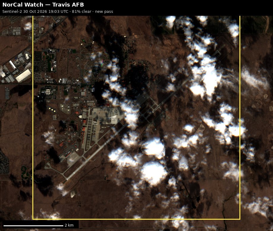
| Travis AFB | 2026-10-30 19:03 UTC, 81% clear | new plate |
| Beale AFB | none clear | |
| Lawrence Livermore National Laboratory | none clear | |
| NAS Lemoore | 2026-10-27 18:54 UTC, 100% clear | no new pass |
| Sierra Army Depot | 2026-10-27 18:53 UTC, 99% clear | no new pass |
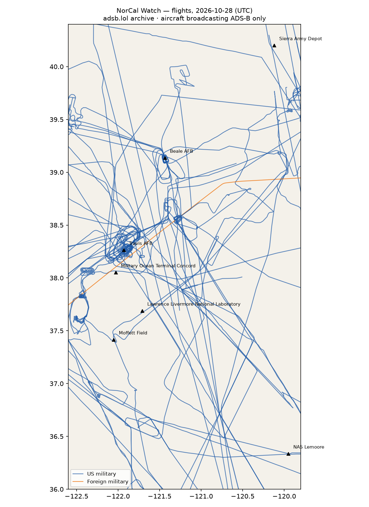
RWI-W-NORCAL-2026-10-29flights 2026-10-28
- 1 foreign military aircraft in the area (Australia).
47 US military · 33 other low · 1 foreign military · 307 heat (0 on sites)
Full report
Northern and central California — airlift, reconnaissance, the weapons lab and the depots. Daily open-source look; flights for 2026-10-28 (UTC), heat for 2026-10-28–2026-10-29, newest satellite passes. LLM-generated and automated.
Notable
- 1 foreign military aircraft in the area (Australia).
Flights
81 aircraft kept: 47 US military, 1 foreign military, 0 state/VIP, 33 other (on the ground at a site, or near a range).
US military
H60 ×6, H47 ×5, T38 ×4, C30J ×4, C130 ×4, ? ×4, C17 ×3, AS65 ×3, BE20 ×2, K35R ×2, C27J ×2, P28A ×2, C5M ×1, B762 ×1, B737 ×1, C560 ×1, P8 ×1, EC45 ×1.
- 68-0213 C5M HEFTY55 at Travis AFB 17:03 UTC
- 65-10342 T38 ASPEN41 at Beale AFB 16:21 UTC
- 14-5864 C30J KING54 at Moffett Field 17:16 UTC
- 64-13285 T38 ROPER06 ROPER31 at Beale AFB 15:27 UTC
- 21-46095 B762 TOGA24 at Travis AFB 03:44 UTC
- 67-14828 T38 ROPER32 ROPER81 at Beale AFB 20:05 UTC
- 169792 B737 CNV4898 at Travis AFB 07:37 UTC
- 06-6157 C17 RCH344 at Travis AFB 18:23 UTC
- 64-13270 T38 ROPER12 at Beale AFB 15:47, Travis AFB 16:31 UTC
- 06-6160 C17 BLINR47 at Travis AFB 02:39 UTC
- 6525 AS65 C6525 at Moffett Field 20:02 UTC
- 59-1508 K35R at Travis AFB 12:37 UTC
- 165755 H60 LASSO01 at NAS Lemoore 01:39 UTC
- 2703 C27J C2703 at Military Ocean Terminal Concord 21:24 UTC
Foreign military
- Australia: A41-212 C17 ASY796 23:15–23:59 UTC
Landings and low passes by site
| Site | Military / government aircraft on the ground or ≤1,500 ft within 4 km; civil count |
|---|---|
| Travis AFB | 06-6160 C17 (BLINR47) 02:39, 21-46095 B762 (TOGA24) 03:44, 169792 B737 (CNV4898) 07:37, 59-1508 K35R 12:37, 64-13270 T38 (ROPER12) 16:31, 68-0213 C5M (HEFTY55) 17:03, 06-6157 C17 (RCH344) 18:23; 2 civil |
| Beale AFB | 64-13285 T38 (ROPER06 ROPER31) 15:27, 64-13270 T38 (ROPER12) 15:47, 65-10342 T38 (ASPEN41) 16:21, 67-14828 T38 (ROPER32 ROPER81) 20:05 |
| Lawrence Livermore National Laboratory | — |
| Moffett Field (NASA Ames) | 14-5864 C30J (KING54) 17:16, 6525 AS65 (C6525) 20:02; 22 civil |
| Military Ocean Terminal Concord | 2703 C27J (C2703) 21:24 |
| NAS Lemoore | 165755 H60 (LASSO01) 01:39 |
| Sierra Army Depot | — |
Heat
307 detections in the watch box (FIRMS area API (agent Gazda)); 0 inside a site box. The Central Valley has seasonal agricultural burning; only heat on a site box is flagged.
| Date | UTC | Lat, lon | FRP | Satellite | Site / nearest |
|---|---|---|---|---|---|
| 2026-10-28 | 0917 | 39.755, -122.054 | 0.84 | N20 | Beale AFB (87.1 km) |
| 2026-10-28 | 0917 | 40.071, -122.194 | 2.22 | N20 | Beale AFB (122.7 km) |
| 2026-10-28 | 0917 | 40.076, -122.188 | 2.22 | N20 | Beale AFB (123.0 km) |
| 2026-10-28 | 0917 | 40.076, -122.194 | 2.22 | N20 | Beale AFB (123.2 km) |
| 2026-10-28 | 0920 | 38.016, -122.116 | 1.39 | N20 | Military Ocean Terminal Concord (8.8 km) |
| 2026-10-28 | 0920 | 39.092, -122.193 | 0.48 | N20 | Beale AFB (65.6 km) |
| 2026-10-28 | 0920 | 39.098, -122.193 | 0.48 | N20 | Beale AFB (65.5 km) |
| 2026-10-28 | 1002 | 38.214, -121.984 | 0.55 | N21 | Travis AFB (7.2 km) |
| 2026-10-28 | 1002 | 39.095, -122.189 | 1.91 | N21 | Beale AFB (65.2 km) |
| 2026-10-28 | 1002 | 39.755, -122.053 | 1.3 | N21 | Beale AFB (87.0 km) |
| 2026-10-28 | 1002 | 39.844, -121.709 | 0.73 | N21 | Beale AFB (82.2 km) |
| 2026-10-28 | 1002 | 40.070, -122.191 | 2.51 | N21 | Beale AFB (122.4 km) |
| 2026-10-28 | 1002 | 40.073, -122.190 | 2.51 | N21 | Beale AFB (122.7 km) |
| 2026-10-28 | 1002 | 40.076, -122.189 | 5.39 | N21 | Beale AFB (123.0 km) |
| 2026-10-28 | 1004 | 36.476, -121.733 | 8.19 | N21 | Moffett Field (NASA Ames) (108.1 km) |
| 2026-10-28 | 1004 | 36.480, -121.732 | 8.19 | N21 | Moffett Field (NASA Ames) (107.8 km) |
| 2026-10-28 | 1004 | 36.534, -121.406 | 0.64 | N21 | Moffett Field (NASA Ames) (113.4 km) |
| 2026-10-28 | 1004 | 36.665, -120.136 | 0.49 | N21 | NAS Lemoore (40.3 km) |
| 2026-10-28 | 1004 | 36.695, -120.581 | 0.53 | N21 | NAS Lemoore (69.2 km) |
| 2026-10-28 | 1004 | 36.712, -121.767 | 0.43 | N21 | Moffett Field (NASA Ames) (82.2 km) |
| 2026-10-28 | 1004 | 37.023, -120.198 | 0.83 | N21 | NAS Lemoore (79.7 km) |
| 2026-10-28 | 1004 | 37.024, -120.196 | 1.01 | N21 | NAS Lemoore (79.6 km) |
| 2026-10-28 | 1004 | 37.184, -121.680 | 0.74 | N21 | Moffett Field (NASA Ames) (41.6 km) |
| 2026-10-28 | 1004 | 37.214, -121.902 | 0.28 | N21 | Moffett Field (NASA Ames) (25.9 km) |
| 2026-10-28 | 1004 | 37.456, -121.934 | 0.43 | N21 | Moffett Field (NASA Ames) (11.2 km) |
| 2026-10-28 | 1004 | 37.882, -121.186 | 0.74 | N21 | Lawrence Livermore National Laboratory (50.7 km) |
| 2026-10-28 | 1004 | 37.949, -122.398 | 1.12 | N21 | Military Ocean Terminal Concord (34.6 km) |
| 2026-10-28 | 1004 | 38.016, -122.113 | 1.47 | N21 | Military Ocean Terminal Concord (8.6 km) |
| 2026-10-28 | 1004 | 38.025, -122.065 | 0.88 | N21 | Military Ocean Terminal Concord (4.5 km) |
| 2026-10-28 | 1041 | 36.479, -121.731 | 4.08 | N | Moffett Field (NASA Ames) (107.9 km) |
| 2026-10-28 | 1041 | 37.455, -121.931 | 0.88 | N | Moffett Field (NASA Ames) (11.4 km) |
| 2026-10-28 | 1041 | 38.017, -122.112 | 1.58 | N | Military Ocean Terminal Concord (8.5 km) |
| 2026-10-28 | 1041 | 38.085, -121.060 | 0.93 | N | Lawrence Livermore National Laboratory (72.0 km) |
| 2026-10-28 | 1041 | 39.093, -122.189 | 0.82 | N | Beale AFB (65.2 km) |
| 2026-10-28 | 1041 | 39.756, -122.053 | 1.09 | N | Beale AFB (87.1 km) |
| 2026-10-28 | 1041 | 39.845, -121.708 | 1.12 | N | Beale AFB (82.4 km) |
| 2026-10-28 | 1041 | 39.846, -121.703 | 0.56 | N | Beale AFB (82.3 km) |
| 2026-10-28 | 1041 | 40.071, -122.190 | 3.62 | N | Beale AFB (122.5 km) |
| 2026-10-28 | 1041 | 40.072, -122.190 | 1.47 | N | Beale AFB (122.6 km) |
| 2026-10-28 | 1041 | 40.075, -122.189 | 3.62 | N | Beale AFB (122.8 km) |
Imagery
| Site | Newest clear Sentinel-2 pass (≤12 days) | |
|---|---|---|
| Travis AFB | 2026-10-20 19:03 UTC, 99% clear | no new pass |
| Beale AFB | none clear | |
| Lawrence Livermore National Laboratory | none clear | |
| NAS Lemoore | 2026-10-27 18:54 UTC, 100% clear | no new pass |
| Sierra Army Depot | 2026-10-27 18:53 UTC, 99% clear | no new pass |
RWI-W-NORCAL-2026-10-28flights 2026-10-27
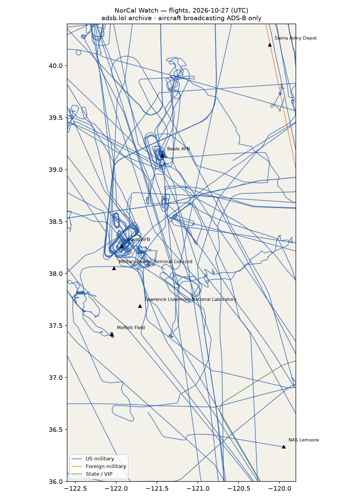
- 1 foreign military aircraft in the area (other).
26 other low · 53 US military · 1 foreign military · 1 state/VIP · 418 heat (0 on sites)
Full report
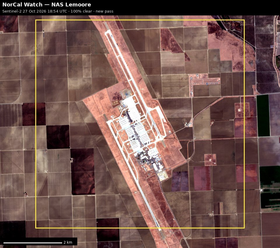
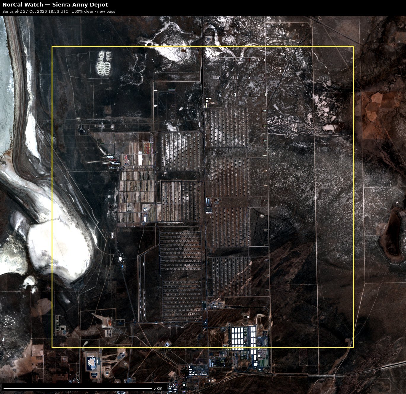
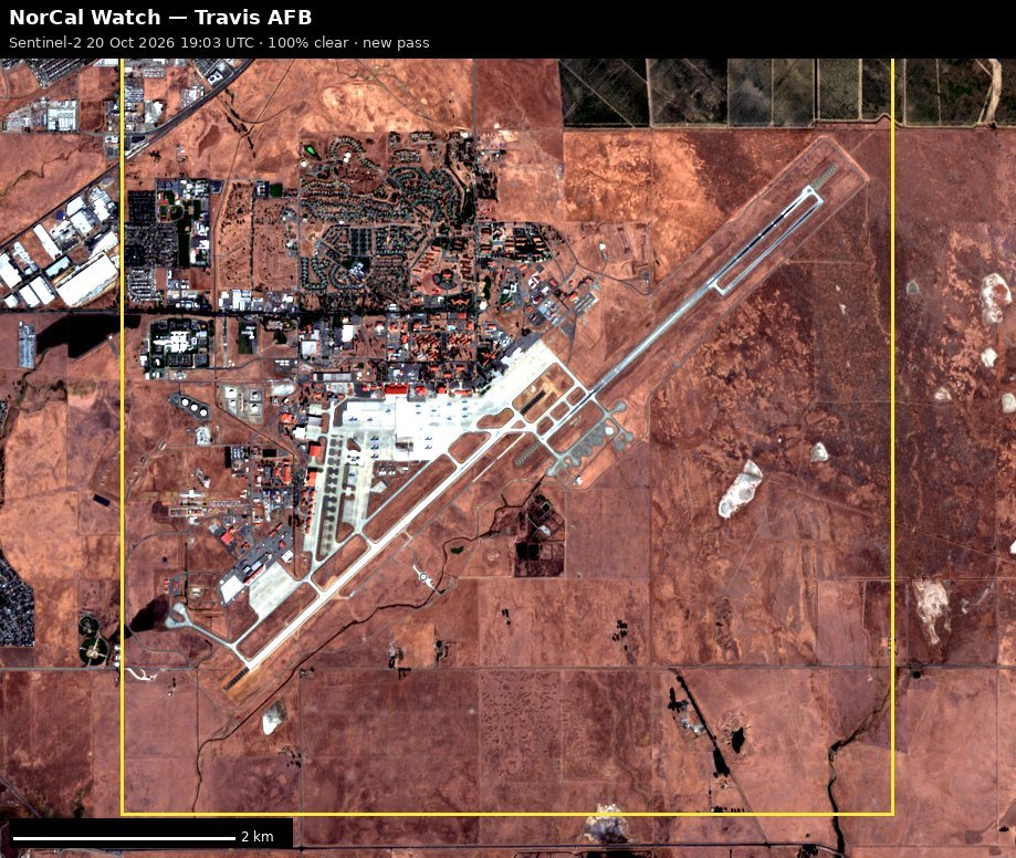
Northern and central California — airlift, reconnaissance, the weapons lab and the depots. Daily open-source look; flights for 2026-10-27 (UTC), heat for 2026-10-27–2026-10-28, newest satellite passes. LLM-generated and automated.
Notable
- 1 foreign military aircraft in the area (other).
Flights
81 aircraft kept: 53 US military, 1 foreign military, 1 state/VIP, 26 other (on the ground at a site, or near a range).
US military
C17 ×8, ? ×7, H60 ×5, AS65 ×3, T38 ×3, C5M ×3, C27J ×3, C30J ×3, H47 ×3, BE20 ×2, C130 ×2, P28A ×2, C172 ×2, C560 ×1, B350 ×1, B762 ×1, K35R ×1, P8 ×1, E2 ×1, EC45 ×1.
- 6525 AS65 C6525 at Moffett Field 16:52 UTC
- 67-14828 T38 ROPER12 ROPER22 ROPER81 at Beale AFB 15:40 UTC
- 06-6160 C17 BLINR27 GRZLY37 at Travis AFB 04:23 UTC
- 68-0213 C5M HEFTY35 at Travis AFB 18:01 UTC
- 65-10342 T38 RECCE02 ROPER31 at Beale AFB 15:15 UTC
- 95-00092 BE20 LOST77 PAT653 at Beale AFB 16:22 UTC
- 98-0056 C17 RCH5002 at Travis AFB 20:54 UTC
- 07-7172 C17 RCH814 RCH987 at Travis AFB 00:42 UTC
- 21-46095 B762 ORCA20 at Travis AFB 16:22 UTC
- ae330a GUCCI21 at Travis AFB 20:10 UTC
- 64-13285 T38 ROPER13 at Beale AFB 19:15 UTC
- 165755 H60 LASSO01 at NAS Lemoore 00:05 UTC
- 59-1508 K35R at Travis AFB 19:44 UTC
- 86-0014 C5M RCH4041 at Travis AFB 00:45 UTC
Foreign military
- other: 98-00010 C560 PAT800 14:05–15:31 UTC
State and VIP
- UR-82027 A124 ANTONOV An-124 Ruslan ADB710F ADB7110 16:22–23:18 UTC
Landings and low passes by site
| Site | Military / government aircraft on the ground or ≤1,500 ft within 4 km; civil count |
|---|---|
| Travis AFB | 07-7172 C17 (RCH814 RCH987) 00:42, 86-0014 C5M (RCH4041) 00:45, 06-6160 C17 (BLINR27 GRZLY37) 04:23, 21-46095 B762 (ORCA20) 16:22, 68-0213 C5M (HEFTY35) 18:01, 59-1508 K35R 19:44, ae330a (GUCCI21) 20:10, 98-0056 C17 (RCH5002) 20:54; 2 civil |
| Beale AFB | 65-10342 T38 (RECCE02 ROPER31) 15:15, 67-14828 T38 (ROPER12 ROPER22 ROPER81) 15:40, 95-00092 BE20 (LOST77 PAT653) 16:22, 64-13285 T38 (ROPER13) 19:15 |
| Lawrence Livermore National Laboratory | — |
| Moffett Field (NASA Ames) | 6525 AS65 (C6525) 16:52; 20 civil |
| Military Ocean Terminal Concord | — |
| NAS Lemoore | 165755 H60 (LASSO01) 00:05 |
| Sierra Army Depot | — |
Heat
418 detections in the watch box (FIRMS area API (agent Gazda)); 0 inside a site box. The Central Valley has seasonal agricultural burning; only heat on a site box is flagged.
| Date | UTC | Lat, lon | FRP | Satellite | Site / nearest |
|---|---|---|---|---|---|
| 2026-10-27 | 0419 | 40.072, -122.191 | 16.06 | Terra | Beale AFB (122.7 km) |
| 2026-10-27 | 0917 | 40.068, -122.192 | 1.7 | N | Beale AFB (122.3 km) |
| 2026-10-27 | 0917 | 40.069, -122.187 | 1.88 | N | Beale AFB (122.3 km) |
| 2026-10-27 | 0917 | 40.070, -122.193 | 1.88 | N | Beale AFB (122.6 km) |
| 2026-10-27 | 0917 | 40.074, -122.192 | 1.7 | N | Beale AFB (122.9 km) |
| 2026-10-27 | 0939 | 37.454, -121.934 | 0.92 | N20 | Moffett Field (NASA Ames) (11.2 km) |
| 2026-10-27 | 0939 | 37.884, -121.186 | 0.76 | N20 | Lawrence Livermore National Laboratory (50.8 km) |
| 2026-10-27 | 0939 | 38.018, -122.117 | 0.67 | N20 | Military Ocean Terminal Concord (8.8 km) |
| 2026-10-27 | 0939 | 40.069, -122.192 | 2.29 | N20 | Beale AFB (122.4 km) |
| 2026-10-27 | 0939 | 40.073, -122.191 | 2.29 | N20 | Beale AFB (122.8 km) |
| 2026-10-27 | 1021 | 37.456, -121.931 | 0.83 | N21 | Moffett Field (NASA Ames) (11.4 km) |
| 2026-10-27 | 1021 | 37.950, -122.397 | 1.08 | N21 | Military Ocean Terminal Concord (34.4 km) |
| 2026-10-27 | 1021 | 38.016, -122.115 | 0.98 | N21 | Military Ocean Terminal Concord (8.8 km) |
| 2026-10-27 | 1021 | 40.069, -122.185 | 2.33 | N21 | Beale AFB (122.1 km) |
| 2026-10-27 | 1021 | 40.070, -122.190 | 2.33 | N21 | Beale AFB (122.5 km) |
| 2026-10-27 | 1021 | 40.074, -122.189 | 2.09 | N21 | Beale AFB (122.7 km) |
| 2026-10-27 | 1058 | 37.942, -122.392 | 0.44 | N | Military Ocean Terminal Concord (34.3 km) |
| 2026-10-27 | 1058 | 38.014, -122.111 | 0.43 | N | Military Ocean Terminal Concord (8.5 km) |
| 2026-10-27 | 1058 | 38.015, -122.115 | 0.43 | N | Military Ocean Terminal Concord (8.8 km) |
| 2026-10-27 | 1058 | 38.087, -121.061 | 0.5 | N | Lawrence Livermore National Laboratory (72.1 km) |
| 2026-10-27 | 1058 | 40.069, -122.190 | 1.49 | N | Beale AFB (122.4 km) |
| 2026-10-27 | 1058 | 40.074, -122.188 | 2.13 | N | Beale AFB (122.7 km) |
| 2026-10-27 | 1117 | 40.072, -122.190 | 2.35 | N20 | Beale AFB (122.6 km) |
| 2026-10-27 | 1754 | 39.087, -121.663 | 27.33 | Terra | Beale AFB (20.4 km) |
| 2026-10-27 | 1754 | 39.641, -122.102 | 29.91 | Terra | Beale AFB (80.3 km) |
| 2026-10-27 | 1754 | 39.755, -122.047 | 41.52 | Terra | Beale AFB (86.7 km) |
| 2026-10-27 | 1754 | 39.759, -122.052 | 31.14 | Terra | Beale AFB (87.3 km) |
| 2026-10-27 | 2002 | 38.251, -120.816 | 11.86 | N21 | Travis AFB (97.2 km) |
| 2026-10-27 | 2002 | 38.253, -120.810 | 11.86 | N21 | Travis AFB (97.8 km) |
| 2026-10-27 | 2002 | 38.257, -120.819 | 11.26 | N21 | Travis AFB (97.0 km) |
| 2026-10-27 | 2004 | 38.327, -121.528 | 23.5 | N21 | Travis AFB (35.9 km) |
| 2026-10-27 | 2004 | 38.328, -121.530 | 12.79 | N21 | Travis AFB (35.7 km) |
| 2026-10-27 | 2004 | 38.330, -121.524 | 12.79 | N21 | Travis AFB (36.2 km) |
| 2026-10-27 | 2004 | 38.516, -121.962 | 14.34 | N21 | Travis AFB (28.3 km) |
| 2026-10-27 | 2004 | 38.520, -121.960 | 13.75 | N21 | Travis AFB (28.7 km) |
| 2026-10-27 | 2004 | 38.544, -121.901 | 20.61 | N21 | Travis AFB (31.4 km) |
| 2026-10-27 | 2004 | 38.546, -121.895 | 19.11 | N21 | Travis AFB (31.7 km) |
| 2026-10-27 | 2004 | 38.578, -122.401 | 10.99 | N21 | Travis AFB (54.0 km) |
| 2026-10-27 | 2004 | 39.087, -121.672 | 5.51 | N21 | Beale AFB (21.1 km) |
| 2026-10-27 | 2004 | 39.088, -121.666 | 5.87 | N21 | Beale AFB (20.6 km) |
Imagery
| Site | Newest clear Sentinel-2 pass (≤12 days) | |
|---|---|---|
| Travis AFB | 2026-10-20 19:03 UTC, 100% clear | no new pass |
| Beale AFB | none clear | |
| Lawrence Livermore National Laboratory | none clear | |
| NAS Lemoore | 2026-10-27 18:54 UTC, 100% clear | no new pass |
| Sierra Army Depot | 2026-10-27 18:53 UTC, 100% clear | no new pass |
RWI-W-NORCAL-2026-10-27flights 2026-10-26
Nothing out of pattern.
28 other low · 30 US military · 379 heat (0 on sites)
Full report
Northern and central California — airlift, reconnaissance, the weapons lab and the depots. Daily open-source look; flights for 2026-10-26 (UTC), heat for 2026-10-26–2026-10-27, newest satellite passes. LLM-generated and automated.
Notable
- Nothing out of pattern.
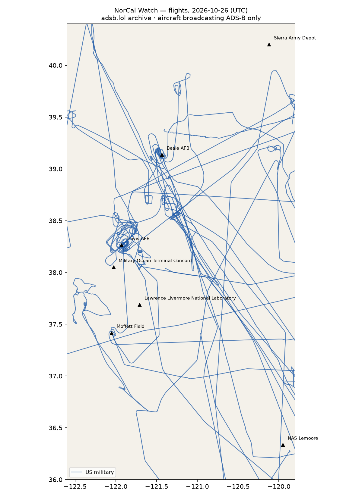
Flights
58 aircraft kept: 30 US military, 0 foreign military, 0 state/VIP, 28 other (on the ground at a site, or near a range).
US military
H60 ×5, C30J ×4, C5M ×3, C17 ×3, BE20 ×2, T38 ×2, C27J ×2, C172 ×2, AS65 ×2, P8 ×1, K35R ×1, ? ×1, B762 ×1, P28A ×1.
- 76-0166 BE20 WAYLN98 at Moffett Field 17:48 UTC
- 170281 C30J 170281 HRCLS25 HRCLS64 at Travis AFB 03:14 UTC
- 64-13270 T38 RECCE02 at Beale AFB 15:51 UTC
- 16-5858 C30J KING54 at Moffett Field 15:22, Travis AFB 15:48 UTC
- 07-7179 C17 RCH148 at Travis AFB 06:49 UTC
- 05-5142 C17 RCH471 at Travis AFB 01:53 UTC
- 68-0213 C5M FRED15 at Travis AFB 17:04 UTC
- 65-10342 T38 RECCE02 ROPER11 ROPER21 at Beale AFB 16:09 UTC
Foreign military
None broadcasting.
Landings and low passes by site
| Site | Military / government aircraft on the ground or ≤1,500 ft within 4 km; civil count |
|---|---|
| Travis AFB | 05-5142 C17 (RCH471) 01:53, 170281 C30J (170281 HRCLS25 HRCLS64) 03:14, 07-7179 C17 (RCH148) 06:49, 16-5858 C30J (KING54) 15:48, 68-0213 C5M (FRED15) 17:04; 3 civil |
| Beale AFB | 64-13270 T38 (RECCE02) 15:51, 65-10342 T38 (RECCE02 ROPER11 ROPER21) 16:09 |
| Lawrence Livermore National Laboratory | — |
| Moffett Field (NASA Ames) | 16-5858 C30J (KING54) 15:22, 76-0166 BE20 (WAYLN98) 17:48; 18 civil |
| Military Ocean Terminal Concord | — |
| NAS Lemoore | — |
| Sierra Army Depot | — |
Heat
379 detections in the watch box (FIRMS area API (agent Gazda)); 0 inside a site box. The Central Valley has seasonal agricultural burning; only heat on a site box is flagged.
| Date | UTC | Lat, lon | FRP | Satellite | Site / nearest |
|---|---|---|---|---|---|
| 2026-10-26 | 0900 | 37.626, -120.997 | 1.06 | N21 | Lawrence Livermore National Laboratory (63.0 km) |
| 2026-10-26 | 0937 | 37.454, -121.934 | 0.61 | N | Moffett Field (NASA Ames) (11.1 km) |
| 2026-10-26 | 0937 | 38.015, -122.114 | 2 | N | Military Ocean Terminal Concord (8.7 km) |
| 2026-10-26 | 0956 | 37.884, -121.184 | 1.12 | N20 | Lawrence Livermore National Laboratory (51.0 km) |
| 2026-10-26 | 0956 | 38.014, -122.112 | 0.83 | N20 | Military Ocean Terminal Concord (8.6 km) |
| 2026-10-26 | 0956 | 38.015, -122.117 | 0.51 | N20 | Military Ocean Terminal Concord (8.9 km) |
| 2026-10-26 | 0956 | 38.217, -121.985 | 0.4 | N20 | Travis AFB (7.0 km) |
| 2026-10-26 | 0956 | 38.315, -121.833 | 0.35 | N20 | Travis AFB (10.3 km) |
| 2026-10-26 | 0956 | 38.316, -121.836 | 0.31 | N20 | Travis AFB (10.1 km) |
| 2026-10-26 | 0958 | 36.416, -120.197 | 0.38 | N20 | NAS Lemoore (23.9 km) |
| 2026-10-26 | 0958 | 36.714, -121.769 | 0.78 | N20 | Moffett Field (NASA Ames) (81.9 km) |
| 2026-10-26 | 0958 | 37.454, -121.931 | 0.52 | N20 | Moffett Field (NASA Ames) (11.4 km) |
| 2026-10-26 | 0958 | 37.455, -121.935 | 0.74 | N20 | Moffett Field (NASA Ames) (11.0 km) |
| 2026-10-26 | 0958 | 37.952, -122.399 | 1.26 | N20 | Military Ocean Terminal Concord (34.6 km) |
| 2026-10-26 | 1041 | 37.880, -121.186 | 0.48 | N21 | Lawrence Livermore National Laboratory (50.6 km) |
| 2026-10-26 | 1041 | 38.014, -122.113 | 2.46 | N21 | Military Ocean Terminal Concord (8.7 km) |
| 2026-10-26 | 1041 | 38.016, -122.113 | 2.18 | N21 | Military Ocean Terminal Concord (8.6 km) |
| 2026-10-26 | 1717 | 38.946, -122.067 | 16.32 | Terra | Beale AFB (58.4 km) |
| 2026-10-26 | 1717 | 38.961, -122.038 | 3.95 | Terra | Beale AFB (55.6 km) |
| 2026-10-26 | 1717 | 39.629, -122.092 | 20.85 | Terra | Beale AFB (78.8 km) |
| 2026-10-26 | 1717 | 39.631, -122.104 | 24.29 | Terra | Beale AFB (79.7 km) |
| 2026-10-26 | 1717 | 39.970, -122.187 | 6.46 | Terra | Beale AFB (113.0 km) |
| 2026-10-26 | 2021 | 36.975, -120.481 | 5.86 | N21 | NAS Lemoore (85.5 km) |
| 2026-10-26 | 2021 | 36.977, -120.479 | 8 | N21 | NAS Lemoore (85.5 km) |
| 2026-10-26 | 2021 | 38.208, -121.603 | 3.45 | N21 | Travis AFB (29.2 km) |
| 2026-10-26 | 2021 | 38.217, -121.548 | 14.33 | N21 | Travis AFB (33.7 km) |
| 2026-10-26 | 2021 | 38.218, -121.545 | 14.33 | N21 | Travis AFB (34.0 km) |
| 2026-10-26 | 2021 | 38.239, -121.336 | 4.03 | N21 | Travis AFB (51.9 km) |
| 2026-10-26 | 2021 | 38.244, -121.338 | 4.36 | N21 | Travis AFB (51.7 km) |
| 2026-10-26 | 2021 | 38.328, -121.615 | 6.41 | N21 | Travis AFB (28.4 km) |
| 2026-10-26 | 2021 | 38.336, -121.540 | 3.74 | N21 | Travis AFB (35.0 km) |
| 2026-10-26 | 2021 | 38.508, -122.002 | 2.57 | N21 | Travis AFB (28.0 km) |
| 2026-10-26 | 2021 | 38.508, -122.002 | 2.94 | N21 | Travis AFB (28.0 km) |
| 2026-10-26 | 2021 | 38.515, -121.890 | 2.53 | N21 | Travis AFB (28.3 km) |
| 2026-10-26 | 2021 | 38.534, -121.898 | 3.99 | N21 | Travis AFB (30.3 km) |
| 2026-10-26 | 2021 | 38.534, -121.898 | 3.14 | N21 | Travis AFB (30.4 km) |
| 2026-10-26 | 2021 | 38.535, -121.895 | 4.04 | N21 | Travis AFB (30.5 km) |
| 2026-10-26 | 2021 | 38.535, -121.894 | 3.9 | N21 | Travis AFB (30.5 km) |
| 2026-10-26 | 2021 | 38.577, -122.399 | 24.72 | N21 | Travis AFB (53.8 km) |
| 2026-10-26 | 2021 | 38.849, -120.892 | 42.14 | N21 | Beale AFB (56.7 km) |
Imagery
| Site | Newest clear Sentinel-2 pass (≤12 days) | |
|---|---|---|
| Travis AFB | 2026-10-20 19:03 UTC, 100% clear | no new pass |
| Beale AFB | none clear | |
| Lawrence Livermore National Laboratory | none clear | |
| NAS Lemoore | 2026-10-27 18:54 UTC, 100% clear | no new pass |
| Sierra Army Depot | 2026-10-27 18:53 UTC, 100% clear | no new pass |