Reporter leads unexplained so far
- RWI-SITREP-020-L1Gaza box: a daytime heat pixel at or beside the Kerem Shalom crossing
Where / when30 Oct 10:36 UTC, NOAA-21: one pixel of 5.9 MW at 31.226 N, 34.291 E, within about 1 km of the Kerem Shalom crossing, where Gaza, Israel and Egypt meet. One pass; the next pass (NOAA-20, 11:32) saw nothing there.
WhyKerem Shalom is the main crossing for goods into Gaza. A 375 m pixel cannot say whether the heat was in the terminal, on the Israeli farmland next to it or across the Egyptian line, and nothing in the reporting we checked for 30 Oct mentions a fire there. The other five Gaza-box pixels that morning are in Israeli farmland or on the perimeter line (section 1.2).
Would settle itCOGAT or the crossing authority on any fire or incident at the terminal on 30 Oct; local reporting; the next clear Sentinel-2 pass.
- RWI-SITREP-020-L2LNG Canada, Kitimat: the daytime heat pair, now partly explained (carried from SITREP 019, L1)
Where / when7 detections between 29 Oct 19:30 and 30 Oct 11:38 UTC, day and night; the largest is still the 19:30 pair (10.9 MW) 0.9–1.4 km south of the plant's usual night flare spot.
WhyThe plant flares around the clock while its flare stack waits for a redesign, and its flaring has been reported for months (CBC, The Narwhal, Al Jazeera). That explains heat at the plant. It does not explain a daytime pair ten times the usual power in a different part of the site; no flaring notice for 29 Oct was found.
Would settle itLNG Canada's flaring notices or the BC Energy Regulator for 29 Oct.
- RWI-SITREP-020-L3The Tunisian military C-130J at St. John's (carried from SITREP 019, L2)
Where / whenZ21122 (TUN82), last seen on the ground at St. John's on 29 Oct at 20:29 UTC. Nothing new in this window.
WhyUnchanged.
Would settle itIts next leg once the ADS-B archive for 30 Oct is read; the airport or the Tunisian embassy.
- RWI-SITREP-020-L4Djibouti and Zawiya spots (carried from SITREP 019, L3–L5)
Where / whenThe Djibouti road spot, the Chabelley runway spot and the Zawiya coast night-burn spot. No pass over Djibouti in the window; Zawiya had a clear Sentinel-2 pass (10:01, change 0.02) and the only heat was at the refinery's flares (00:58), about 9 km west of the coast spot.
WhyUnchanged.
Would settle itAs in SITREP 017.
- RWI-SITREP-020-L5Carried forward, unchanged: the open leads of SITREPs 008–015 (carried from SITREP 019, L6)
Where / whenAs listed in SITREP 017.
WhyNothing in this window touches them.
Would settle itAs in the original reports.
Summary
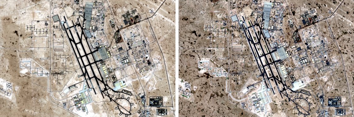
REVISED – FINAL, replacing the withdrawn GPT versions (BENCH-010). The biggest imagery change, Al Udeid at 0.54, is haze in the baseline, not activity: Ras Laffan on the same pass darkened the same way. One daytime heat pixel at the Kerem Shalom crossing is unexplained; the other Gaza-box pixels are Israeli farmland or the perimeter. Two front-line pixels north-east of Orikhiv match reported shelling there. 32 of 45 optical passes were cloud.
Window 29 Oct 2026 18:52 UTC → 30 Oct 2026 18:52 UTC
For journalists public while testing
Suggested request for comment: LNG Canada daytime heat, 29 October 2026
On lead RWI-SITREP-020-L2 · sent to 1 account · also public while testing
For: LNG Canada media relations, and the BC Energy Regulator (compliance and enforcement). About: RWI SITREP 020, lead L2 (carried from SITREP 019, L1). A draft for a journalist to adapt and send; RWI does not send it.
What we saw. NASA's FIRMS fire data (VIIRS on NOAA-21) recorded two hot pixels at the LNG Canada site in Kitimat on 29 October 2026 at 19:30 UTC (12:30 PDT): 10.9 MW each, at 54.016 N, 128.676 W and 54.012 N, 128.685 W. That is 0.9–1.4 km south of the spot where the plant's flare usually shows up at night. Earlier detections at the plant (nine on 20–26 October) were all at night and 0.4–1.5 MW. Seven more detections followed through 30 October 11:38 UTC.
What it does and does not show. A satellite pixel is about 375 m across. It shows that something hot burned there at that time; it cannot say what. The plant's continuous flaring has been widely reported. This event was by day, about ten times the usual power, and in a different part of the site. We found no public flaring notice for 29 October.
Suggested questions for LNG Canada
- Was there a flaring, upset, maintenance or other combustion event at the Kitimat facility on 29 October 2026 around 12:30 PDT?
- Which flare system or equipment was it, and where on the site? The heat was 0.9–1.4 km south of the main flare.
- How long did it last, and what volume of gas was burned?
- Was a public flaring notice issued? If not, why not?
- Was it reported to the BC Energy Regulator as an unplanned or non-routine event?
Suggested questions for the BC Energy Regulator
- Did LNG Canada notify the regulator of a flaring or other event on 29 October 2026?
- Does the event fall under the corrective actions or the non-compliance investigation the regulator has described for the facility's flare systems?
- Were any air-quality readings in the Kitimat Valley elevated that day?
Suggested deadline: two working days. Credit: "Roger Wilco Imagery (Prime Rogue Inc.), SITREP 020, lead L2"; thermal data "NASA FIRMS".